GIS Without
Boundaries
Bring point clouds, vector data, and imagery together in one powerful cloud-native platform. Accessible from anywhere, on any device.
Already have an account? Log in here.
Live Demo
Experience SkyGIS
Explore a live project right in your browser. No installation required.
Open Live Demo
Explore the full interactive platform
Click anywhere to launch
Platform Capabilities
Everything you need. Nothing you don't.
A unified platform that eliminates software installs, handles every major spatial data format, and scales effortlessly from solo surveyors to enterprise fleets.
SkyGIS Core
Essential tools to view, measure, and collaborate
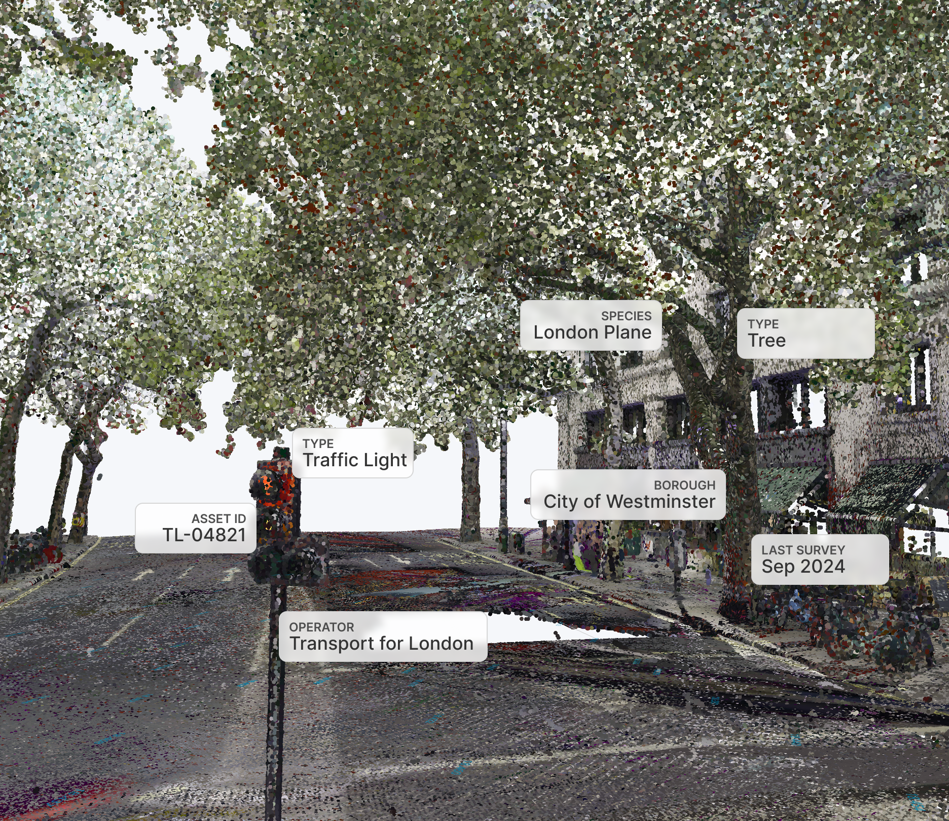
Point Cloud & Data Display
View point clouds, vectors, images, and CAD/BIM models together in one browser-based environment — no plugins required.
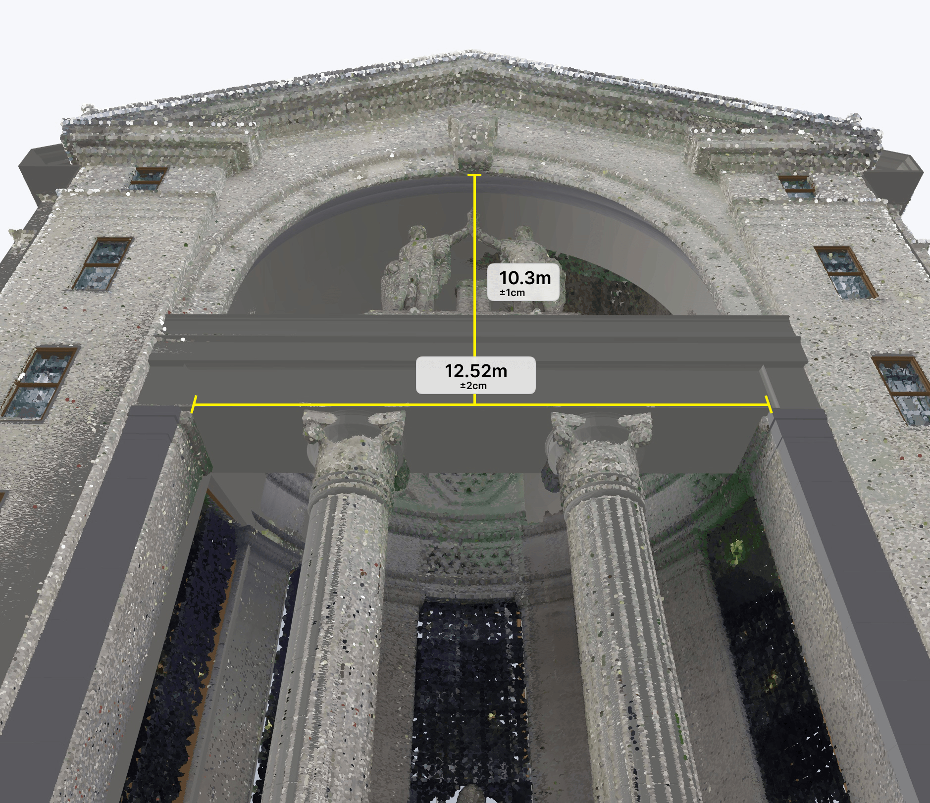
Measurement Tools
Measure distances, elevations, and areas directly on your 3D data — calculate surface areas and volumes without switching to desktop software.
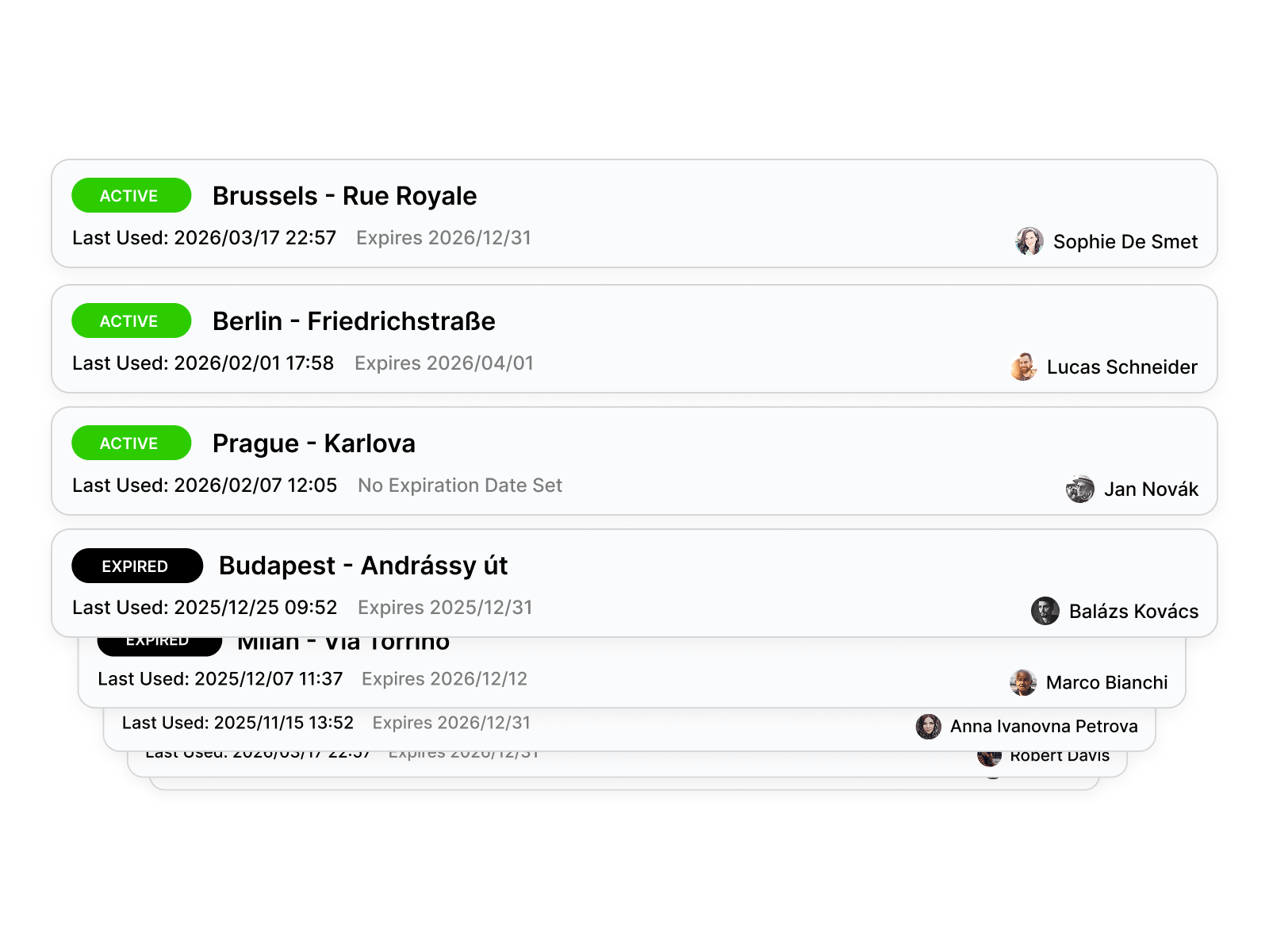
Secure Project Sharing
Share any project with a link — optionally protected by a password. Stakeholders open it in their browser and see the full 3D dataset instantly, with access fully under your control.
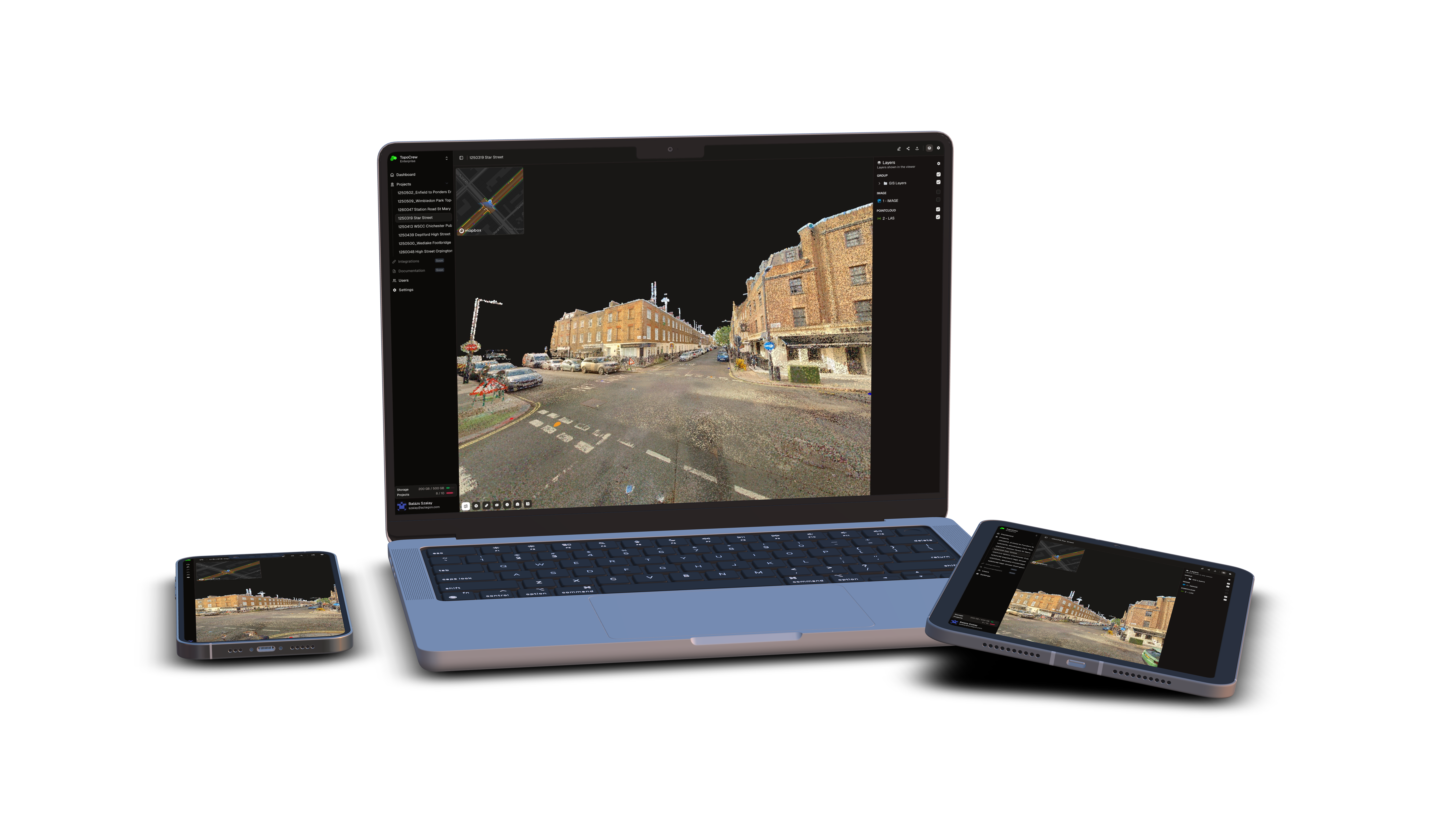
Cross-Platform Access
Works on Windows, Mac, Linux, and iPad. Any modern browser, any device — zero installs.
Cloud-Scale Storage
Handle datasets from megabytes to terabytes. Data lives in the cloud with no local storage constraints.
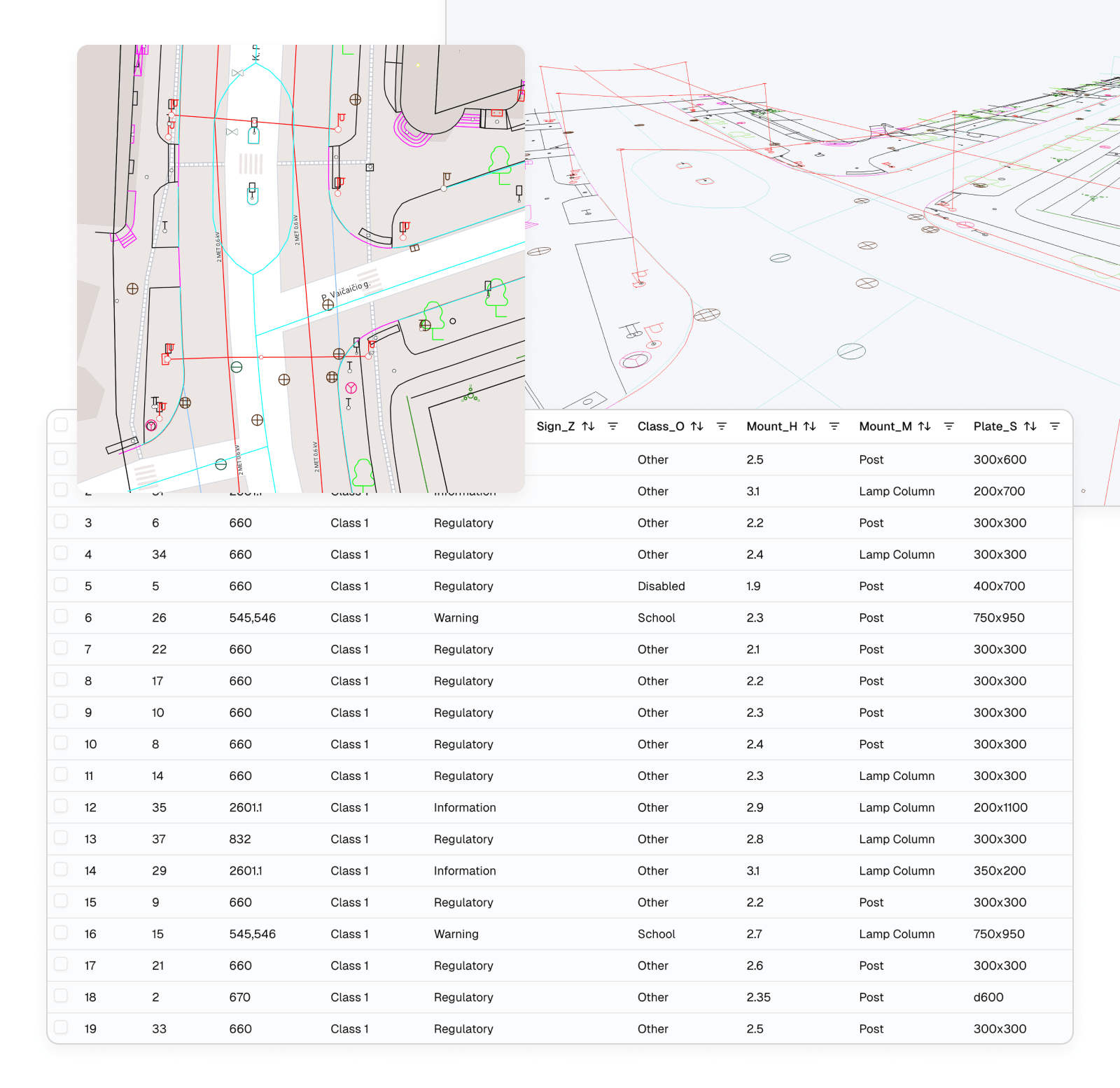
Attribute Management
View, edit, and manage element attributes. Attach files to objects and modify properties per element.
What you gain
- Instant access anywhere with a browser and internet
- Single source of truth for every stakeholder
- Measure areas and distances directly in the browser — no desktop software needed
- Share securely with password-protected links you control
- Scalable from megabytes to terabytes
Problems we solve
- Eliminate expensive desktop software, high-end hardware, and IT approvals.
- Stop shipping hard drives — share password-protected links instead.
- Get area and volume measurements on-site without waiting for the office.
- Replace restrictive local storage with scalable, high-performance cloud infrastructure.
- Synchronize field teams and stakeholders through streamlined web workflows.
SkyGIS PlusAvailable Soon!
Advanced tools for power users and teams
Custom Branding
Apply your company logo, colors, and identity to the platform. Your clients see your brand, not ours.
Clip Box Export
Define a selection box to isolate and export specific parts of a point cloud — no more downloading entire datasets.
GIS Toolkit
Perform buffer, clip, merge, split, and select-by-location operations on vector data directly in the browser.
SQL Queries
Query attribute tables with SQL-powered filters. Find, sort, and export exactly the data you need.
Client Data Upload
Clients of your organization can upload their own data for collaborative review.
WMS
Connect to external Web Map Services to overlay additional map layers without downloading data.
What you gain
- Advanced asset management with batch operations
- Custom branding enhances your client experience
- GIS operations directly in the browser
- Clients can upload their own data for collaborative review
Problems we solve
- Compare CAD designs with as-built conditions directly in the browser.
- Perform precise cloud-based stockpile calculations without heavy software.
- Create high-fidelity Digital Twins and Gaussian Splatting for investor-grade presentations.
- Integrate CAD, LandXML, and RCS formats for seamless long-term archiving.
SkyGIS EnterpriseAvailable Soon!
Full control, compliance, and field-ready tools
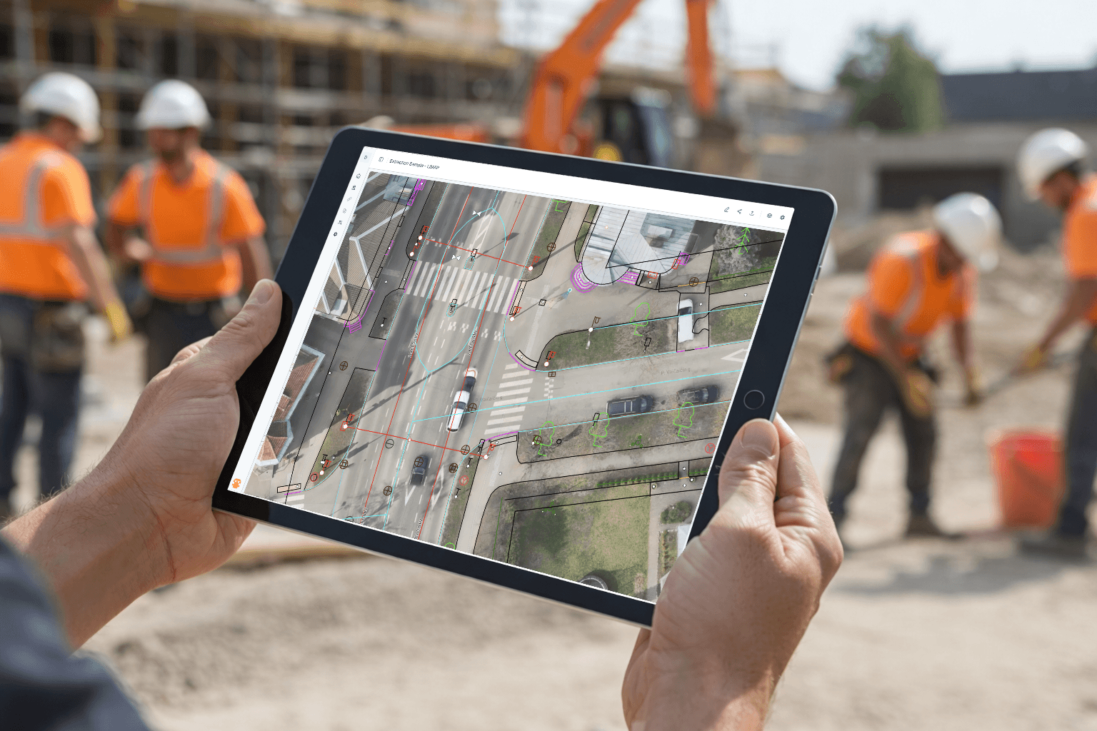
Mobile App
Access and interact with data on-site from a tablet. Perform field checks, update records, and sync changes in real time.
Smart Archiving
Archive inactive projects with a few clicks. A fraction of the storage cost, instantly restorable when needed.
Custom Domain
Host the platform on your own domain for a fully branded, professional experience for your organization.
Expert consulting
Maximize your project's potential — unsure which scanner, data format, or workflow fits your spatial data? Our experts guide you from strategy to execution.
Full GIS Suite
Complete toolkit for point cloud, raster, and vector manipulation — advanced operations beyond the Plus GIS toolkit.
Single Sign-On
Enterprise-grade SSO for seamless integration with your organization's identity system.
What you gain
- Access and modify data on-site from a tablet
- Deep insight into raster and point cloud data
- Never worry about storage — archive with a few clicks
- Know exactly what your users are doing
Problems we solve
- Ensure purpose-driven laser scanning through expert consulting.
- Enable real-time mobile quality control and faster on-site decisions.
- Allow stakeholders to digitize and annotate point clouds in-browser — no CAD required.
- Turn complex 3D data into cinematic flythroughs for non-technical audiences.
The new standard for spatial data
Built for surveyors, engineers, mapping specialists, and professionals who need to upload, view, and collaborate on massive datasets — without local processing or complex setup.
From E57 point clouds to GeoTIFF imagery, everything runs instantly in the browser. Sky has no limits.
Trust & Compliance
Security by design
Your data is encrypted at every layer, isolated in private networks, and stored with full redundancy in European data centers.
Encrypted everywhere
AES-256 encryption at rest for every file and database record. TLS-secured connections in transit — your data is never exposed.
Signed & expiring links
Shared links are cryptographically signed with built-in expiration and optional password protection. No one accesses your data without authorization.
Redundant & backed up
Your data is replicated across multiple availability zones with automated daily backups and point-in-time recovery.
EU-hosted infrastructure
All data is processed and stored in European data centers. Backend services are fully isolated from the public internet.
Versioned storage
Every file upload is versioned automatically. Accidental overwrites or deletions are recoverable.
Built for durability
Intelligent storage tiering keeps your data cost-efficient and instantly accessible — from megabytes to terabytes.
Core Use Cases
Essential Workflows
Every SkyGIS plan starts here — the essential capabilities that replace desktop software with a single browser tab.
Survey & Production Support
Inspect point clouds, browse scan imagery, check vectors and designs — the standard workflow for land surveyors and GIS professionals. Everything runs in the browser with zero installs.
- Visual QA directly on the point cloud
- Upload and overlay vectors for verification
- Built-in measurement tools for distance & area
Project Sharing
Share projects with clients, reviewers, and stakeholders via a simple link. No installs, no accounts — they open it and see the data immediately.
- One-click sharable links with expiry control
- No registration required for recipients
- Full interactive 3D experience
Scanner Sales & Demos
Upload data from various scanners and run live demos in the browser — impressive and effortless.
Heritage Conservation
Store and share scanned heritage sites. Unified access for researchers, architects, and conservation teams.
Crime Scene Investigation
Standardize how scanned crime scene evidence is reviewed across teams and jurisdictions.
Raster from Point Cloud
Create raster images from top-down views for a comprehensive overview of your point cloud.
Plantation Management
Combine UAV datasets with GIS layers of individual trees for precision agriculture and forestry.
Basic Asset Management
Manage objects with attributes, attach files, and modify properties per element.
Plus Use Cases
Tools for power users
Go beyond viewing — design review, stockpile calculation, compliance archiving, and more.
Regulatory Compliance & Long-Term Data Retention
Archive large point clouds at a fraction of their original cost for multi-year preservation. Instantly restore data when needed for audits or regulatory reviews.
BIM/AEC Coordination
Combine IFC building models with point cloud scans to detect clashes, verify as-built conditions, and coordinate between design and construction teams in a shared browser environment.
Road & Rail Infrastructure Inspection
Load LandXML alignments alongside point cloud surveys to verify earthwork geometry, check clearances, and document deviations from design. Ideal for contractors and infrastructure owners managing linear assets.
Earthwork Volume Tracking
Track earthwork volumes, stockpile quantities, and terrain changes with survey-grade precision directly from UAV or terrestrial point clouds. Monitor cut and fill progress against design intent to ensure accurate data for billing and progress tracking.
Utility Network Management
Overlay WMS utility layers (gas, water, electric) with point cloud site surveys to plan excavations safely, identify conflicts, and document as-built underground infrastructure.
Quarry & Mining Progress Monitoring
Use stockpile calculation and selection tools to measure extracted material per zone across time, combining UAV point clouds with WMS geological or cadastral layers for regulatory reporting.
Enterprise Use Cases
Built for scale
Field-ready mobile access, collaborative vectorization, cinematic visualization, digital twin publishing, and strategic consulting.
Collaborative Web-Based Vectorization
Draw, digitize, and annotate directly on the point cloud in-browser — no CAD installation required. Ideal for quick markups, collaborative planning, and minor design adjustments.
Field Data Collection & Verification
Use the mobile app to capture, upload, and verify point cloud and vector data directly on-site, closing the loop between field crews and office-based engineers without manual file transfers or version conflicts.
City & Infrastructure Digital Twin Publishing
Serve processed datasets as Outbound WMS layers to municipal GIS platforms, smart city dashboards, or third-party systems — while consuming Inbound WMS feeds to keep the scene contextually up to date.
Full Survey-to-Deliverable Pipeline
Run complete file conversions, vector editing, and point cloud manipulation within a single platform — eliminating external desktop tools and enabling end-to-end project delivery from raw scan to final client output.
GIS Consultancy & Custom Data Production
Leverage built-in expert consultation to design and execute complex workflows combining data from multiple sensor types. Produce bespoke spatial datasets that fuse these sources into unified, client-ready deliverables tailored to project or regulatory specifications.
Disaster Assessment & Emergency Planning
Rapidly ingest and convert multi-source scan data from affected areas, manipulate vector and point cloud layers to assess structural damage, and publish results as Outbound WMS feeds to emergency coordination systems or government platforms.
Pricing Plans
Transparent & scalable
Graduated pricing per 100 GB. The more you store, the less you pay.
Personal
Lite
€714/yr
100 GB included
1 user
- Sharable link
- Measure tools
- Panoramic images
- Max 5 projects
- 100 GB storage (fixed)
- Attribute management (view only)
- LAS, TXT clouds
- DXF, SHP vectors
- POI functions
- GeoTIFF ortho support
- TLS, MLS, ALS, ULS, SLAM
Starter
Core
€1,428/yr
€70/100 GB/mo at 200 GB
Up to 10 users
- Everything in Lite
- Unlimited projects
- Unlimited storage (tier-based)
- e57, LAZ cloud formats
- DWG, GeoJSON vectors
- Full attribute editing
Professional
Plus
€1,836/yr
€90/100 GB/mo at 200 GB
Unlimited users
- Everything in Core
- Branding
- SQL query
- RCS cloud format
- LandXML, IFC vectors
- Stockpile calculation
- Selection box + export
- Basic GIS toolkit
- Limited file conversions
- WMS support (inbound)
- Google Street View
- Project archive
- Client data upload (session)
- Xgrids splat support
- JPG2000 ortho format
Custom
Enterprise
Contact Us
Custom pricing
Unlimited users
- Everything in Plus
- Mobile app
- DGN, CityGML, NWD vectors
- Advanced GIS tools
- Full file conversions
- WMS inbound/outbound
- ECW ortho format
- SSO
- Custom domain
- Vector editor
- Video module
- Professional consulting
- Client data upload (storage)
Contact
Get in touch
Questions or want a live demo? We'd love to hear from you.
Or email us directly at hello@skygis.cloud